
How CoolMinds built an offline-first survey platform with location verification and offline data synchronization for an organic spice company. It helped onground surveyors check community farms to flag potential inconsistencies before external certification audits for example to authenticate their organic practices and check for inputs like organic use of fertilizers, pesticides and insecticides.
Executive Summary
*client-reported numbers
About the Client & Platform
The client sourced spices such as cardamom, cinnamon, nutmeg and pepper wholesale from farming communities across southern India. It is then packaged and sold in retail to consumers in Europe. To get an organic produce tag in these regions, it is important to attain and avail organic certifications (particularly by bodies like US Department of Agriculture, EU organic certification - Eco-cert and Kiwa). It depended on the farms satisfying certain conditions: farms keeping strict standards like using - 1) no external fertilizers 2) having sound soil and equipment, 3) properly storing inputs. External inspectors would audit the farms later, and the client wanted to find problems before they did.
FarmTrace gave the client a transparent tech-enabled self-survey process. Local surveyors visited farms with nuanced detailed questionnaires on the Android FarmTrace platform. The results fed reports the client used to judge each farm's chances for satisfying the organic criteria.
The Gap: How Verification Worked Before FarmTrace
Before FarmTrace, farm checks relied on manual, paper-based surveys. A surveyor visited a farm, filled in forms by hand, and the paperwork was later collated and reviewed in the office. That process rested on trust, and trust was where it was weakest.
| Manual process | The gap | What FarmTrace changed |
|---|---|---|
| Paper forms filled in by hand | Forms could be completed after the visit, backdated, or lost | Answers captured on the device at the farm and stored digitally |
| The surveyor's word that a visit happened | No independent proof of presence | Location tag, location lock, vicinity lock and on-site photos |
| Farmer-reported output reviewed by eye | Inflated volumes, or non-organic produce mixed into organic lots, were hard to spot | Expected yield estimated from historical records and comparable farms, with unusual deviations flagged |
| A close surveyor-farmer relationship | Nothing in the process to question a friendly report | Cross-checks against history and peer farms made unusual results visible |
| Records filed on paper | Hard to rebuild a farm's crop year when auditors arrived | A digital record per farm and crop year, linked to pack traceability |
| Reports compiled by hand | Slow, inconsistent, hard to audit later | Reports generated from the survey data, verified by the surveyor, then emailed to PlantOnOrganic after the checks |
The change was simple: every survey now left a digital trail that could be checked, instead of a paper one that had to be taken on trust.
The Engineering Challenge
- Dispersed farms, patchy connectivity. Surveys had to work with no internet and were located in remote far off locations and in long distances.
- Trust in the survey itself. The system was designed in a way to have checks and balances to make it hard for surveyors to skip farm visits. It made it difficult for surveyors to collude with farmers, or for farmers to mix their produce with non-organic produce into organic lots to inflate volumes.
- Non-technical surveyors. They were recruited from nearby areas, needed only brief training, and worked with questionnaires in their local language.
- Audit-ready reporting. Findings had to reach the client as verified, consistent reports.
- Consumer visibility. Buyers wanted to see where each pack came from.
How the Fraud Controls Worked
| Control | How it worked | Risk addressed |
|---|---|---|
| Geotagged surveys | Each survey was tagged with the surveyor's location | Surveys not done on the farm |
| Location lock | The app became unusable if location services were switched off, until they were switched back on | Hiding absence by disabling location |
| Vicinity lock | Forms couldn't be completed away from the farm. Partial data could be submitted, but the rest couldn't be filled in remotely | Completing forms from elsewhere |
| On-site photos | Farm photos had to be uploaded in real time at the location | Reused or staged evidence |
| Plot mapping | Surveyors marked plot locations and recorded acreage on the questionnaire | Inflated farm size |
| Yield cross-checks | Expected output was estimated from current farm statistics and previous years' records, compared with similar farms, and checked against a standard deviation | Mixing in non-organic produce; surveyor-farmer collusion |
| Stated error margin | Estimates carried a 5% to 12% variance depending on climate, noted in each report | Over-flagging genuine variation |
| Document verification | Surveyors verified farm documents at the start of each crop year | Gaps in the paper trail |
Visit frequency depended on farm size, crop type and the crop's growing cycles. To note that cardamom, nutmeg and pepper follow different seasons.
Technology Architecture & Platform Specifications
| Layer | Specification |
|---|---|
| Mobile app | Native Android app for field surveyors. Offline-first: questionnaires were completed without a connection and stored in a local on-device cache |
| Offline sync | "Store now, upload later." Completed surveys and photos uploaded when connectivity returned. A Java backend component handled the sync |
| Location services | Device location drove survey tagging, the location lock and the vicinity lock |
| Backend | Java and J2EE application layer for survey ingestion, yield cross-check logic and reporting |
| Database | MySQL holding farms, plots, crops, surveys, historical yields and reports |
| Media | Farm photos captured on site and uploaded with each survey - compression type |
| Reporting | Reports generated from survey data, verified by the surveyor, then emailed to PlantOnOrganic |
| Traceability | Crop-year records captured through the app and linked to each pack through QR code |
| Language | Questionnaires in the surveyors' local language |
How the offline model worked. Surveyors completed questionnaires fully offline, and responses and photos stayed in the local cache. When a connection was available, the app uploaded the completed surveys, and the Java backend processed them for review and reporting. Cross-checks against historical and peer data were applied to each survey.
Farm-to-Pack Traceability
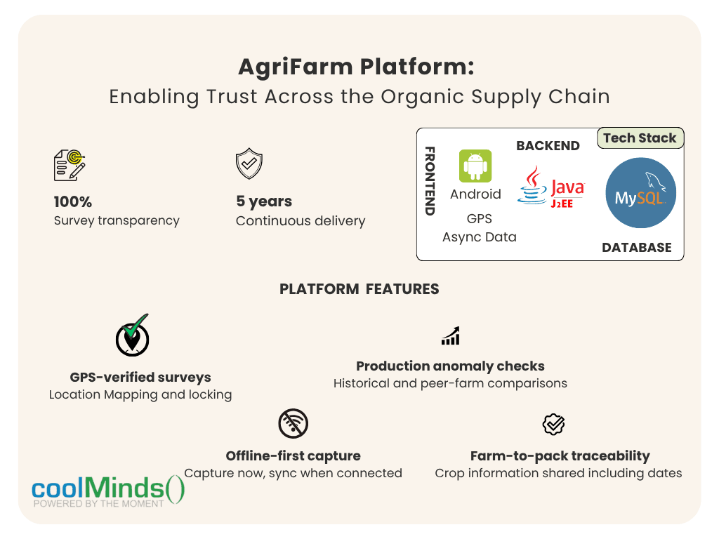
Each pack could tell its own story. A buyer could see when the crop year opened, which farm area it came from, when it was harvested and dried, where it was packed and stored, and how it was shipped, with each stage recorded through the survey process.
Team and Delivery
| Role | Count |
|---|---|
| Java/J2EE developers | 3 |
| Android developer | 1 |
| Architect and project manager | 1 |
| Database engineer | 1 |
Business Outcomes & Impact
- Strong audit results. Most surveyed farms went on to pass USDA and EU organic certification audits. The pre-audit surveys let the client spot likely failures before the external inspectors arrived.
- Client confidence. The client valued the transparent model and singled out the design, deployment and features, especially how well the controls discouraged fraudulent surveys.
- Five years of continuous delivery, with new features released every month.
Running an Organic or Compliance-Driven Farm Program?
Talk to us about field inspection technology.
Talk To Our Team